

As the Mountains Surround Jerusalem, God Surrounds His People
Updated: Aug 21
By John W. Moore
"For the Lord has chosen Zion; he has desired it for his dwelling place." — Psalm 132:13
"As the mountains are around Jerusalem, so the Lord is around his people." — Psalm 125:2
It is early morning on the Sabbath during Ramadan, and a peaceful calm blankets the Old City of Jerusalem. Most of the Jewish and Muslim communities are locked away at home, and many shops lie closed inside their respective quarters. It's my favorite part of the day. At the Western Wall, you mostly hear the chorus of birds flying to nests tucked in the cracks of the massive stones, along with the low murmur of prayer. If you let your imagination wander, you can almost hear the crowds of ancient history on pilgrimage to the temple, celebrating the redemption of Israel with their families. It's the perfect time to visit, when you feel as though you have the whole city to yourself, with ample time to stop, reflect, and pray.

The Old City has a unique aura. From its ancient defensive walls to its ornately crafted gates, history is written all over it. Its buildings, ancient and modern alike, wear the look of antiquity, and its limestone streets are polished smooth by centuries of foot traffic. As you wander, the Christian Quarter stirs with the quiet voices and hurried steps of pilgrims longing to walk where Jesus walked.
Near the Jaffa Gate, you'll often see Haredi Jews in traditional black attire, moving purposefully toward the Western Wall to pray. The scent of fresh bread mingles with jasmine and za'atar as the markets along the narrow streets slowly come to life. As you wander deeper into the alleys, you notice ancient architecture, art, and walls scarred by Jerusalem's tumultuous past. Hundreds of thousands arrive here each year, most longing to be closer to God, some seeking confirmation of their faith, and others simply observing the devotion of others.
Walking the streets of what is arguably the most important city in the world gives you a clear sense of its religious history and fervor, but it also gives you a bit of a workout. Jerusalem isn't always conducive to a light, leisurely stroll, and its hills present real challenges for anyone with limited mobility. Moving between quarters means climbing up and down sizable hills and valleys. As the psalmist wrote in Psalm 125:2, Jerusalem was built on several hills, surrounded by more hills and valleys. Reaching the Temple Mount inevitably means walking up, then down, then up again. In some places, that climb is quite noticeable, but within each hill and valley lies part of the story of Jerusalem's history, expansion, and the temple itself. In many ways, the topography shaped the city's development and the temple's story as well.

LOCATION AND APPROACH
Because of its defensible location, reliable water source, and sacred sites, Jerusalem has always been a prized and cherished city, a natural home for the temple. Situated in the Judean hill country of southern Israel, it lies roughly thirty-three miles east of the Mediterranean and fifteen miles west of the Dead Sea's northern tip, nestled at the southern edge of the tribal territory of Benjamin. The Hinnom Valley, just south of the city, marks the boundary between Judah and Benjamin, first established during the Israelite conquest of Canaan (Joshua 11:18-20). At roughly 2,500 feet above sea level, Jerusalem's terrain is a patchwork of small hills and significant valleys. Its location mattered greatly to King David, who sat just south of an important crossroads on the central Benjamite plateau, giving him easier access to govern his nation and to reach trade routes and military objectives to the east and west.
Travelers reached Jerusalem via one of four major approaches. The first came from the north, via the central Benjamite plateau (Judges 19-20; 1 Samuel 12:1-9; 2 Chronicles 16:1-6). The second came from the south, along the Judean Ridge Route through Bethlehem and Hebron (Judges 19:1, 10; 1 Samuel 17; 2 Chronicles 20:2, 20), known today as "the Way of the Patriarchs" for its heavy use by the families of Abraham, Isaac, and Jacob and for being the easiest route from the Negev into the southern hill country.
The third approach, from the west, was far more difficult. The hills of the Shephelah and the deep, V-shaped valleys carved into the hard Judean limestone made travel rugged and treacherous. Jerusalem was easier to reach along the north-south ridge route than from the coast or the Rift Valley, which kept the city somewhat removed from the major coastal trade routes, but it gained the security of natural defenses in exchange (Rasmussen 188).
The fourth approach came from the east, via the ascent of Adummim from Jericho through the Judean Wilderness, passing the Mount of Olives. Jesus and His family often took this route to Jerusalem for worship, and it was the route of His entry into the city during the week of His crucifixion (2 Samuel 15:23, 30; Matthew 20:17, 21:1-12; Luke 19:41-44, 24:50-53). Because the Mount of Olives stands higher than the temple's mount, a traveler crossing its summit would suddenly be greeted by the full splendor of the temple and the city surrounding it, whether in David's smaller city or in the temple's later glory. A pilgrim's approach from the east meant a sudden, overwhelming view of magnificent walls and buildings set within God-designed hill country.

It was along this eastern approach that the prophet Jeremiah traveled from his hometown of Anathoth to Jerusalem on many trips. I can imagine him reaching the crest of the Mount of Olives one evening, greeted by the glow of the candlelit temple courts and their great ivory pillars. I can also imagine what he felt when he saw that same skyline later, ablaze under Babylonian siege, after having spent much of his ministry warning Jerusalem of the judgment their idolatry and moral decay would bring, including his great sermon of denunciation delivered within those very temple courts (Jeremiah 7). That geographical vantage point alone adds weight and emotion to the temple's story as we try to see it through the eyes of those who first walked it.
TOPOGRAPHY
The Mountains
Ancient builders prioritized two things above all when choosing a city site: high ground for defense and a reliable water source. Jerusalem met both.
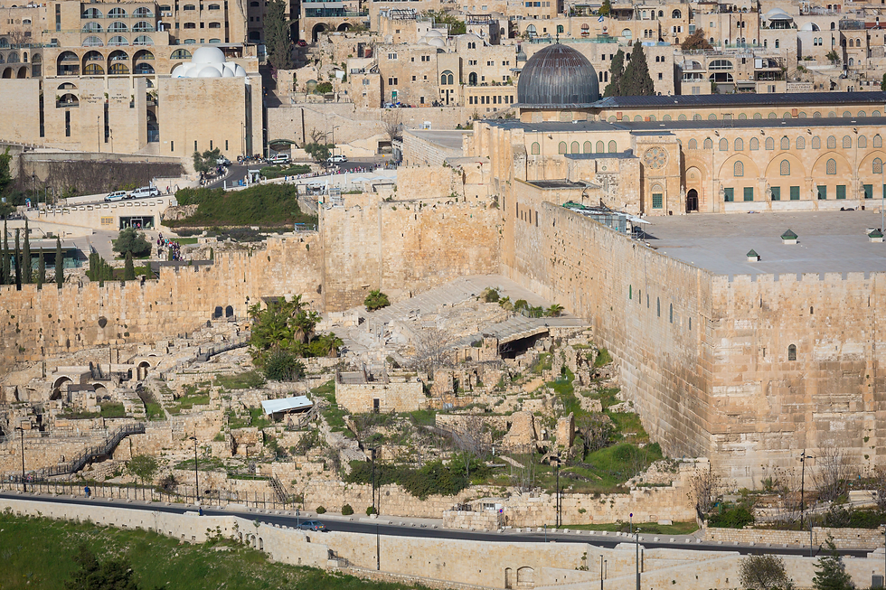
Ophel, standing 2,200 feet above sea level (Nehemiah 11:21; 2 Chronicles 27:3), forms today's southern extension of the Temple Mount, though centuries of excavation and expansion have blurred its once-distinct outline. Its southern spur, sometimes called the Eastern Hill, is a peninsula-shaped ridge bordered to the east by the Kidron Valley, to the west by the Central (Tyropoeon) Valley, and to the south by the Hinnom. This spur held the ancient City of David, his palace, and the original Jebusite stronghold, along with Early Bronze Age remains dating to roughly 3000 B.C. Just east of it lies the Gihon Spring, the constant water source that sustained the city's lower residents as Jerusalem later expanded westward. As the population grew, so did the city's boundaries, its walls, and the challenges those hills and valleys posed for the temple's expansion.
Mount Zion is harder to pin down, having been identified with three different locations over the centuries. In Hebrew literature, it symbolized God's dwelling place (Psalm 125:1) more than a fixed spot, though by the First Temple period it was most often associated with the Temple Mount. Scholar J. Carl Laney identifies Zion with the Spur of Ophel, based on its frequent pairing with the City of David (e.g., 2 Samuel 5:7). Modern visitors, however, will find "Mount Zion" labeled on the Western Hill, home to the traditional site of David's tomb, the Armenian Quarter, and the Citadel. This misidentification dates back to early pilgrims who assumed the larger, higher Western Hill must be the temple's true location. Only in the modern era did clear evidence establish that the City of David and the Temple Mount lie east of the central valley, not west. The "Mount Zion" on today's maps, in other words, isn't the Mount Zion of the biblical era.
Mount Zion is also closely tied to Mount Moriah, "traditionally identified as the mountain in 'the land of Moriah,' upon which Abraham offered Isaac" (Laney 171), and to the site where David purchased a threshing floor from Ornan the Jebusite, which later became home to both the first and second temples (2 Samuel 24:18-25; 2 Chronicles 3:1). The name "Moriah" means "foreseen by God," a striking thought: God foresaw, on this very ground, both Abraham's willingness to sacrifice Isaac and, centuries later, the sacrifice of His own Son.

The Western Hill, mentioned above as the mistaken "Mount Zion," became part of the city during the westward expansions of Kings Uzziah and Hezekiah in the 8th and 7th centuries B.C. (2 Chronicles 26:6-15; 32:5). By Jesus's day, it housed the homes of Jerusalem's upper and middle classes, the Hasmonean Palace, the high priest's residence, and Herod's mansion. Crusaders later identified the alleged sites of David's tomb and the Upper Room here as well (Laney 172). Today's Old City wall, built by Suleiman the Magnificent (1520-1566), runs west through the center of this hill before turning north along its ridge.
East of the city, a long ridge runs north to south, parallel to the Kidron Valley, and includes both the Mount of Olives and the Hill of Offense. The Mount of Olives rises to 2,700 feet and first appears in Scripture in 2 Samuel 15:30, during David's flight from Absalom. Jesus returned here often (John 8:1; Mark 11:1; Matthew 24:3, 26:30), prayed in the Garden of Gethsemane at its base, and ascended to the Father from its summit (Acts 1:9-12). Ancient olive trees near that base have long been associated with the traditional Gethsemane site, though Scripture never pairs the word "garden" with "Gethsemane." The name itself means "place of the press," and just north of the traditional garden, a cave containing an ancient olive press has been discovered, leading many to believe this cave, not the garden, was where Jesus and His disciples spent that final night before the crucifixion.

South of the Mount of Olives, along the same ridge, lies the Hill of Offense, where Solomon built pagan altars to Chemosh and Molech to honor his foreign wives (1 Kings 11:1-7), corrupting Israel's worship until Josiah tore them down (2 Kings 23:13). Given the topography, it's sobering to realize that temple worshippers could likely see those pagan shrines perched on a nearby hill, perhaps hidden from view within the temple's colonnaded porches, yet plainly visible from higher ground or from just outside the temple to the south.
Now, zoom out beyond the city's own internal hills, and notice that Jerusalem is surrounded by a wider ring of higher hills. To the north stands Nebi Samwil, traditionally identified with ancient Mizpah, rising to roughly 2,920 feet, the highest point in the immediate vicinity. To the east, Mount Scopus reaches about 2,710 feet, and the Mount of Olives, at 2,700 feet, stands just above Jerusalem's own elevation of around 2,500 feet. Together with the hill country stretching south and west, these heights form a literal ring around the city, the same "bowl" effect described below in the section on the valleys.
These surrounding hills are precisely the image the psalmist had in mind in Psalm 125:1-2: "They that trust in the Lord shall be as Mount Zion, which cannot be removed, but abideth for ever. As the mountains are round about Jerusalem, so the Lord is round about his people, from henceforth even for ever." The psalmist wasn't reaching for a vague metaphor; instead, he was describing an actual, visible feature of the landscape that any worshiper standing in the city could see with their own eyes: a real ring of higher ground surrounding Jerusalem on every side. Just as those encircling hills gave the city a sense of settled security, so God's presence surrounds His people, not as some poetic abstract idea but as a real, abiding, all-sided protection that really exist and one with which its readers would have been familiar.
The Valleys
Picturing ancient Jerusalem requires thinking in three dimensions, not two. Imagine the city sitting on two parallel ridges within a large bowl, with the bowl's rim rising higher than the ridges within it. The western ridge, higher and broader, is bounded on the west by the Hinnom Valley, which begins northwest of the city, turns south, then east, marking the ridge's western and southern limits. The narrower, lower eastern ridge is bounded on the east by the Kidron Valley, which runs north to south before joining the Hinnom and continuing southeast through the Judean desert to the Dead Sea. Between these two ridges lies a valley the Bible never names, known to geographers as the Central Valley, or the Tyropoeon, the "Valley of the Cheesemakers." To the north, both ridges continue to rise as they curve northwest, and the valleys, the Hinnom, the Central, and a tributary of the Kidron, veer in that same direction. A west-east valley feeding into the Central Valley forms the western ridge's natural northern boundary, while the eastern ridge's northern limit rises more gradually, broken only by minor depressions draining into the Bezetha Valley.

The elevation changes are dramatic. The crest of the Western Hill stands 2,536 feet above sea level, while the meeting point of the Kidron and Hinnom Valleys sits roughly 615 feet lower, at about 1,921 feet above sea level, a striking drop over a short distance. To the north, between the Temple Mount and the Mount of Olives, the change in elevation isn’t as steep, but the difference is still impressive and formidable. In Bible times, these valleys made Jerusalem difficult to attack from the south, east, or west, forcing any invading army to fight uphill, which is why fortifications were concentrated on the more vulnerable north side. The Kidron Valley is also known for its dark history as a site where idols were burned in worship of Baal and Ashtoreth before King Josiah destroyed them (2 Kings 23:4-6). It was also the valley Jesus and His disciples crossed on their way from the Upper Room to Gethsemane (John 18:1). The Hinnom Valley carried a similarly grim reputation as a site of child sacrifice to Baal and Molech (2 Chronicles 28:3; 33:6).
WATER SOURCES
No resource mattered more to an ancient city than water, used for drinking, cleansing, and sustaining crops. Jerusalem's primary source was the Gihon Spring on the eastern side of the Eastern Hill. Early in the city's history, builders cut a vertical shaft through the city wall to the pool at the mountain's base, securing a constant water supply. In the 8th century B.C., Hezekiah famously dug a tunnel from the Gihon Spring westward through the base of the Ophel spur to the Pool of Siloam, bringing the spring's water safely inside the city wall while sealing it off from outside access, denying any invading army its use (2 Kings 20:20; 2 Chronicles 32:30). That tunnel still exists and is open to visitors today.

Jerusalem also relied on cisterns and pools built to capture rainwater runoff, used mainly to water (and wash) animals and crops and, in desperate times, for drinking and bathing as well. Water from hill-country springs and cisterns was carried or channeled to pools and baptisteries throughout the city. The Pool of Bethesda, just north of the Temple Mount, is where Jesus healed the infirm man in John 5, while the Pool of Siloam, at the city's southern end on the western side of the Ophel spur, is where He healed the blind man in John 9. Other pools included the Tower Pool in the western part of the city and the Serpent's Pool just west of the Upper City. Archaeologists have also uncovered more than 150 mikvot (ritual immersion baths) in and around the Old City, many near the Temple itself, confirming the Jewish practice of ritual purification before entering the Temple or observing feast days.
CONCLUSION
Jerusalem's hills and valleys are not merely a footnote to its history; they are its history. Every approach to the city, whether from the plateau of Benjamin, the ridge road of the patriarchs, or the long climb up from Jericho, required travelers to descend before ascending, to pass through low, difficult ground before ever reaching the high place where God chose to dwell. Perhaps that is the enduring lesson tucked into this ancient terrain: our own walk with God rarely runs along flat, easy ground. We too pass through our share of valleys, seasons of struggle, doubt, or grief, on the way to the mountaintop moments of worship and peace. Yet the same God who gave Jerusalem's residents a hidden, constant spring to sustain them through siege and hardship promises the same to us today: a steady, unfailing source of grace and hope for whatever climb lies ahead. And just as the psalmist wrote, "as the mountains are around Jerusalem, so the Lord surrounds his people" (Psalm 125:2), we can walk our own hills and valleys with confidence, trusting that God surrounds us on every side of the journey, not only at the summit but at every step along the way.
Works Cited and Sources
Bahat, Dan. The Illustrated Atlas of Jerusalem. Translated by Shlomo Ketko, Carta, 1996.
Laney, J. Carl. Concise Bible Atlas: A Geographical Survey of Bible History. Baker Book House, 1998.
Rasmussen, Carl G. Zondervan Atlas of the Bible. Rev. ed., Zondervan, 2010.


Comments